|
Jaime Lerner, the author of Urban Acupuncture, recommends that people draw a map of their city to get a feel for it. By drawing a map, one sees, with their eyes, what parts of a city are important to oneself. On his book tour, Jaime Lerner had a Toronto official draw a map of Toronto, and the official found the act enlightening. He drew all the major features he knew, along with all the features that were important to himself. He also drew the “pinpricks” he played a part in adding to Toronto, and he loved seeing all the work that he had done to the city visually. His map became a key part of Jaime Lerner’s presentation. 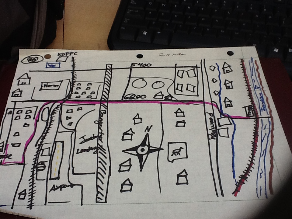 Our class was tasked with drawing our own maps of where we live. I initially misinterpreted the assignment to be drawing a transect, and I spent hours creating one only to learn, once class began, that I drew the wrong kind of map. So during class I quickly drew a new map of West Jordan, where I grew up. ... there is a lot of room for improvement.  Our maps have a simplicity that makes them pleasurable. Scale and accuracy (and the direction of North) matter little; it’s the details that are drawn that give the map its character. Since I lived in the same house for eighteen years, there were numerous little details for me to draw, most of which could not fit on my map. I can’t say I’m thrilled to have lived eighteen years in a suburb; I’ve stated numerous times how droll suburbs are. However, I like the idea of having lived in one place for eighteen years, especially after having talked to people who moved around a lot. There is one place in the world where I can truly call myself a local and that I understand better than most people. When I drew my map on the whiteboard and presented before the class, I could name all sorts of details that people who haven’t lived here as long as I have would think about. I could remember when Jordan Landing, a major shopping center, was just an empty field. I could remember when the Olympic Oval was being constructed and the route that the torch took, turning at the intersection of Cougar Lane and 6200 S. I know which parts of my neighborhood are “new” (in the sense that area was not developed when I moved here) and which are “old.” I feel a connection to where I grew up, an integration of place into my identity that not everyone can enjoy. With that said, there is a lot of room for improvement. One major feature of my maps is a line marking my weekday commute. I have a line that marks the route of the 62 bus that takes me from my house to the Trax station, and a red line for the Red Line train that takes me from the Fashion Place West station to the University of Utah. These lines, though not a tangible place or thing, are major parts of my daily life. And there is room for improvement. Specifically, the bus system in Salt Lake City has a lot to be desired. Transferring from the bus to the train is not so bad, but transferring from bus to bus, or even from train to bus, can be very painful. The bus runs so infrequently and lines up so poorly with the red line train (later in the day, at least; early in the morning it arrives just in time to catch the train) that long layovers can extend one’s commute by hours. I remember when I commuted by bus from my house to the Taylorsville Redwood campus of Salt Lake Community College; a 15-20 minute one-way commute ran over an hour, and I would find myself standing in freezing weather outside waiting for a bus for extended periods of time, with my best option for a seat being an electrical box at the intersection of Redwood Rd. and 6200 S. It was a miserable experience that made me hate the bus. 6200 S. certainly could use more buses, which may be able to ease the massive traffic jams in the morning and afternoon. Truth be told, the entire bus system needs to be expanded if Salt Lake City wants to make it a viable alternative to cars. ... I don’t want [the] field to go away. But something fascinating was a feature I didn’t want changed. Every evening (at least before the school semester kicked into high gear and I lost all recreational time), I would go on a walk along my favorite route. I would walk east on Daffodil Ave., take a right at Clernates, a right at the stop sign, then walk until I reached the edge of my neighborhood and right before a large open field. I would cross the street then walk up the dirt path (likely trespassing) that wove through this field, under the power lines, and to a park with a paved path that circled it. I’d walk around the park and back where I came, with a view of the valley beyond. It’s such a peaceful walk, the closest thing to nature near my house that I can get.
I have always seen the area where I live as being under almost constant development. New houses have been built around the field and I am surprised that the field itself has not been developed. This is likely only a pause to the nonstop development. Truth be told, I don’t want that field to go away. That is the only direction I can walk where the monotony of houses is broken and I can walk through something undeveloped. I would rather not see that direction turn to housing as well. We could turn it into a park or nature preserve, but truth be told I’d rather not see it changed at all. The Zen it currently possesses is enough. I feel like after mapping out my “stomping grounds” (as a former professor of mine once called her home region), I grew a little closer to them. The suburbs are hardly ideal, and I really don’t want to live in suburbs for the rest of my life; a downtown apartment or condominium, or a house out in the country, would likely suit me better. However, West Jordan is where I grew up, and for better or worse, West Jordan is a part of me.
0 Comments
Leave a Reply. |
AuthorCurtis Miller is an instructor and graduate statistics students at the University of Utah. Archives
June 2016
Categories
All
|
 RSS Feed
